Transport Projects (2020)
1) South-to-East Link Road
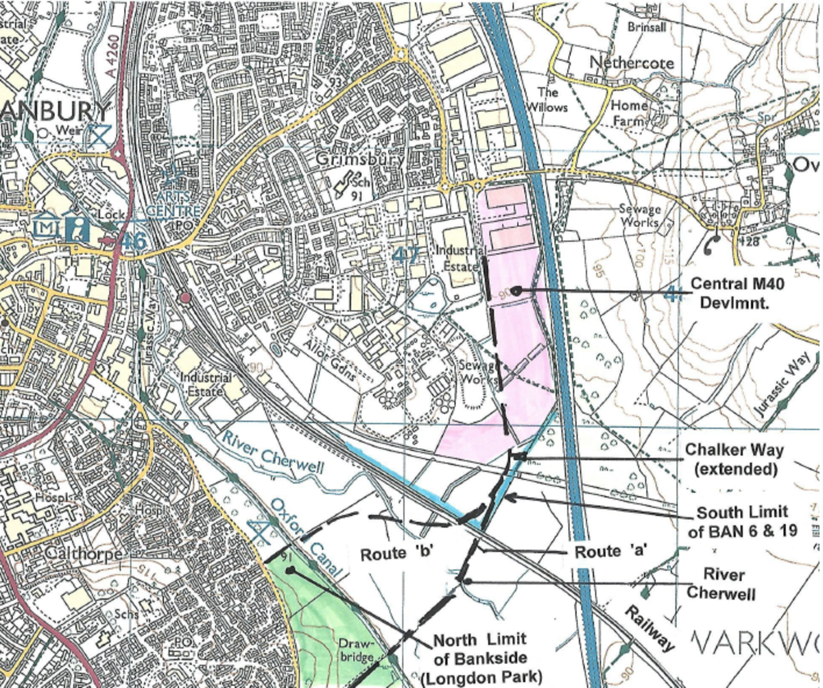
The South-to-East link road, is a proposal for a new road across the Cherwell valley from Bankside to Chalker Way (just west of the M40). This proposal has been around for a long time as, the provision of a third east -west route across the Cherwell valley, would potentially improve access to the M40 AND divert traffic away from the town centre.
A provisional alignment for the road runs from Bankside (near the junc. with Chatsworth Drive) crossing the canal, river and railway to join with Chalker Way, which parallels the M40 (shown as "Route 'a'" on the map below; Route 'b' is no longer viable due to the subsequent construction of the railway maintenance depot.). Alternative connections to M40 are possible.
The Society has been assiduously championing the inclusion this idea through the Local Plan and Vision & Master Plan processes and it became even more attractive after the Local Plan Inspector recommended that the two separate spine roads, one each serving the constituent parts of the Ban17 area (south of Salt Way between the Bloxham and White Post Roads, and sometimes referred to as the Salt Way Link), should be joined to provide a link between the A361 and the Bodicote Flyover.
We will continue to promote this scheme in the up-coming review of the Local Plan as potentially, the BAN17 link, together with the South-to-East road, would provide a third crossing of the valley between the A361 and the M40, thereby enabling 'through traffic' to avoid the town centre and the congested Hennef Way by way of this southern by-pass'.

2) Higham Way extension.
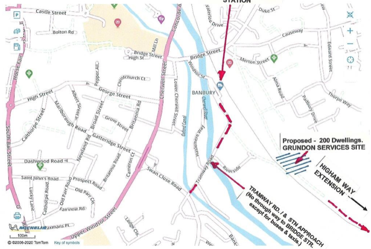
North and east of a new bridge to take the S-to-E link road over the railway there is land lying south of the Thorpe Industrial Estate, which is scheduled for development under the Local Plan ( BAN 6 & 19). An extended Higham Way could connect Merton Street with Chalker Way, thus providing road access to this area AND offer a second access to the railway multi-storey car park. However the route traverses a site owned by Grundon Services for which planning permission for 200 dwellings is being sought as anticipated in the Local Plan.. Whilst the provision of additional social housing in this area is obviously desirable, It is arguable whether this site, which adjoins a busy 24/7 railway is the right location for housing, and it will be interesting to see what the Planning Committee decide.
3) Central M40 and Public Art.
This is the area of development between Chalker Way and the motorway which comprises a number of large industrial units providing employment for Banbury and the locality. The units are easily recognised by their size and the low, curved roofs. Two more units (Nos. 8 &9) at the south end of the area have recently been approved and it is understood these will contain a bakery enterprise, so significant traffic generation (employees and deliveries) is likely. Strengthening of the local highway network to improve accessibility must therefore be given consideration.
The outline planning permission also requires the provision of an item of Public Art as part of the development, this to be located on the inside of the bend at the junction of Chalker Way and the proposed S-to-E road. The initial sketch design shows a column mounted figure representing 'Industry' (see planning portal Ref. 19/02443/CDC) . We await the reality with interest.This item will join the others in the inventory of 'Public Art' around Banbury. The others are……? ? - answers on a postcard, please.
4) Hennef Way & Southam Road / Tesco roundabout
The traffic capacity of Hennef Way has, for some time, been problematic and this has been a concern when a number of planning applications have been considered in the recent past. An application, last year, to increase the through-put of Messrs Tarmac's aggregate depot between the railway and the reservoir (application since withdrawn), focused attention on the traffic volume using Hennef Way, and especially the increased noise and emissions that would result. gave rise to a presentation on this aspect to the County Council by residents and local Councillors.This furore, together with a number of very inconvenient traffic 'traffic-jams' at the Southam Road and Lockheed roundabouts, produced conversations at the Banbury Traffic Advisory Committee, resulting in the County Council officers undertaking to review the situation.
The upshot has been a proposal to relieve Junction 11, and Hennef Way, of the component from and to the north by constructing north-facing slip roads to the M 40 from Southam Road at Hardwick Hill (near Banbury Cemetery). Consultants re now working on this concept and they are also looking at what can be done to ease the situation in the vicinity of Tesco's store and the Banbury Cross trading estate.More information will be given when it comes available BUT as the motorway traffic will still arrive at the Southam Rod roundabout, this arrangement is unlikely to result in any improvement to the town's congestion problems.
5) Access to Railway Station.
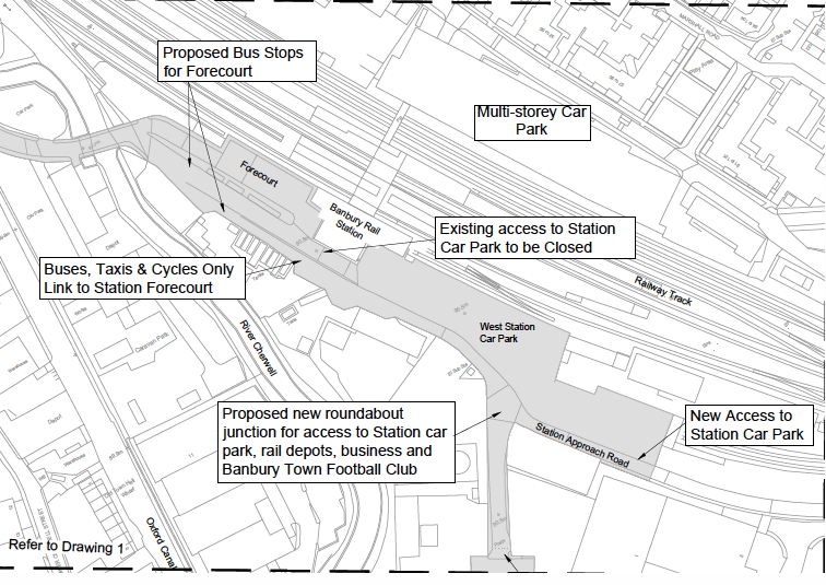
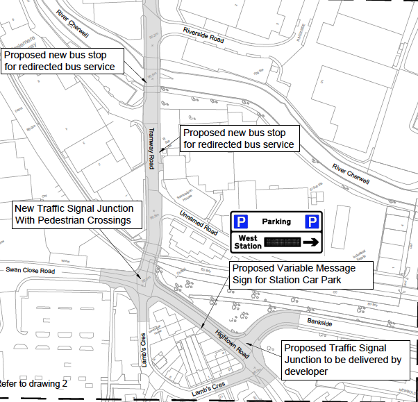
It has long been the Society's ambition that better interchange arrangements between bus, taxi, car and train services should be created. The Canalside redevelopment proposals of a few years ago made some progress towards this ,but nothing has transpired so far.More recently the County Council is developing a scheme to open a vehicle route to the station via Tramway Road ( about time, too, do we hear ?). This will be primarily for buses and taxis, but will also give access from the south and west to the existing surface-level railway car park.The proposal has disadvantages as it would extend the journey times of those bus services approaching via George Street and also the B3 would not be able to call at the stops serving Morrison's supermarket. Buses would continue through the station forecourt to Bridge Street via the existing Station Approach. Other traffic would not be allowed to use this as a through way by imposition of a 'buses only' restriction (Bus Gate) opposite the station building.
The Society does not believe this will meet the desired objective and is suggesting an alternative scheme involving the provision of a new road opposite George Street at Cherwell Street as part of the Canalside construction, with a setting down / pick up point in Lower Cherwell Street. Thereafter services would proceed to the Bus Station or Bridge Street as now ( see diagrammatic street layout attached).Passengers for train services would proceed on foot to the railway station via bridges (hopefully covered) over the canal and river as envisaged in the Canalside plan.This does not realise the Society's ambitions completely, but it would bring bus / rail interchange much closer, and with greater convenience, than now.


6) Bus Services and Stops
In November 2017 a number of changes to bus routes and stopping places were made by the operator with the agreement of the County Council. These mainly affected service B4 by rerouting the service away from the residential area, school and shops at Hanwell Fields - although the vehicle continued to follow almost the whole of the former route in order to turn round to reach the new 'terminus' at Dukes Meadow Drive by Southam Road. BCS has argued that that was enough time in the schedule for the bus service to continue round Lapsley Drive AND also proceed to the Hardwick Hill, (Southam Road) cemetery - a 'calling point' previously not served.
Generally the Society believes that a frequent and reliable public transport service is required if traffic conditions are to be significantly reduced across the whole of the town and local movement is to be restored to acceptable levels.We also believe that good publicity of service stopping points and frequency is essential for the health of the town's commerce and community.
7) Banners & Direction Signs.
The Society considers the proliferation of banners (on guardrails etc) and developer's direction signs (both of authorised design and those of an ad hoc nature) to create un-necessary clutter and distraction for motorists and detract from the appearance of the town environment. In many cases the former become out-of-date and/or bedraggled . They are also illegal. Some direction signs might be useful, but with developer's publicity and the widespread use of 'sat-nav' devices there is little need for the widespread display of the 'black on yellow' direction signs that so disfigure the town.
To this end the Society has suggested a 'Code of Practice to the District Council to control the use of these items. We have received no feedback on this point, although the incidence on banners on pedestrian guardrails has considerably reduced - probably due to schools being closed and other activities being reduced due to 'social distancing' etc'.
We will keep members updated if the situation changes, but if the opportunity arises some pressure on Councillors would not come amiss.